


Livonia Twp. P-2, Sherburne County, Minnesota
About
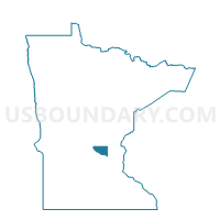
Outline

Summary
| Unique Area Identifier | 604393 |
| Name | Livonia Twp. P-2 |
| County | Sherburne County |
| State | Minnesota |
| Area (square miles) | 18.02 |
| Land Area (square miles) | 16.99 |
| Water Area (square miles) | 1.03 |
| % of Land Area | 94.28 |
| % of Water Area | 5.72 |
| Latitude of the Internal Point | 45.42411670 |
| Longtitude of the Internal Point | -93.54275260 |
Maps


Graphs
Select a template below for downloading or customizing gragh for Livonia Twp. P-2, Sherburne County, Minnesota


Neighbors
Neighoring Voting District (by Name) Neighboring Voting District on the Map
- Baldwin Twp. P-1, Sherburne County, MN
- Baldwin Twp. P-2, Sherburne County, MN
- Elk River W-2 P-2A, Sherburne County, MN
- Elk River W-2 P-2B, Sherburne County, MN
- Livonia Twp. P-1, Sherburne County, MN
- Nowthen P-1, Anoka County, MN
- Saint Francis P-1, Anoka County, MN
- Spencer Brook Twp. Voting District, Isanti County, MN
- Stanford Twp. Voting District, Isanti County, MN
- Zimmerman P-1, Sherburne County, MN
- Zimmerman P-2, Sherburne County, MN
Top 10 Neighboring County Subdivision (by Population) Neighboring County Subdivision on the Map
- Elk River city, Sherburne County, MN (22,974)
- St. Francis city, Anoka County, MN (7,218)
- Baldwin township, Sherburne County, MN (6,739)
- Livonia township, Sherburne County, MN (5,951)
- Zimmerman city, Sherburne County, MN (5,228)
- Nowthen city, Anoka County, MN (4,443)
- Stanford township, Isanti County, MN (2,267)
- Spencer Brook township, Isanti County, MN (1,589)
Top 10 Neighboring Place (by Population) Neighboring Place on the Map
- Elk River city, MN (22,974)
- St. Francis city, MN (7,218)
- Zimmerman city, MN (5,228)
- Nowthen city, MN (4,443)
Top 10 Neighboring Unified School District (by Population) Neighboring Unified School District on the Map
- Elk River Public School District, MN (66,807)
- St. Francis Public School District, MN (31,633)
- Princeton Public School District, MN (20,347)
Top 10 Neighboring State Legislative District Lower Chamber (by Population) Neighboring State Legislative District Lower Chamber on the Map
- State House District 16B, MN (52,029)
- State House District 48A, MN (45,476)
- State House District 17A, MN (45,406)
- State House District 16A, MN (43,791)
Top 10 Neighboring State Legislative District Upper Chamber (by Population) Neighboring State Legislative District Upper Chamber on the Map
- State Senate District 16, MN (95,820)
- State Senate District 17, MN (94,415)
- State Senate District 48, MN (86,286)
Top 10 Neighboring 111th Congressional District (by Population) Neighboring 111th Congressional District on the Map
Top 10 Neighboring Census Tract (by Population) Neighboring Census Tract on the Map
- Census Tract 301.01, Sherburne County, MN (11,300)
- Census Tract 301.02, Sherburne County, MN (7,374)
- Census Tract 501.16, Anoka County, MN (4,443)
- Census Tract 1306, Isanti County, MN (3,897)
- Census Tract 501.07, Anoka County, MN (2,934)